The Crested Butte News Serving the Gunnison Valley since 1999


Forest Service looking deeper into the matter: “It’s complex…”
by Mark Reaman
Confrontation over easements to one of the most popular hikes in the county reached a boiling point this weekend. The trail to Scarp Ridge provides sweeping views of wilderness and is relatively easy to get to above Lake Irwin. But the public trail goes through or skirts property owned by Scarp Ridge LLC, a subsidiary of the Eleven Group.
For many years people would drive to the old Irwin Lodge on a road with a public Forest Service easement and park in the lodge parking area. The current lodge owners have tried to discourage that practice the last several years, citing the dangers and liability of trespassing issues at the lodge.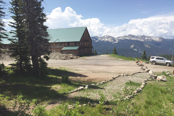
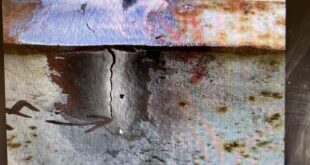
So last week the property owners hired a private surveyor to delineate the road from the private lodge property. On Tuesday, June 30, they placed large rocks at the marked property line. They also put in a short delineated path from the end of the road to the Scarp Ridge trail to guide hikers to the public access. Eleven is essentially prohibiting parking in its lodge lot but allowing access for people to get to the Forest Service trail for hiking. That did not make members of the Lake Irwin Coalition (LIC), a group of property owners in the area, happy.
A series of emails and photos of the boulders and the parking situation were sent out all weekend by the LIC. The photos show several vehicles parked within the 60-foot wide easement along the road. The LIC claims the public easement goes beyond the boulders.
In an email to the Eleven Group, LIC president David Gottorff wrote, “The purpose of this email is to notify you that you have illegally placed boulders and a chain gate within the FS Road 826.1C easement boundaries. While you do have the right to put up boulders where the easement boundaries and your property meet, in this instance you have placed your boulders and chain gate before the legal end of the easement’s boundary. Your blocking of a legal right of way has created both an access and safety issue for those who wish to travel this public right of way.”
Gottorff makes the claim that the photos clearly show the easement continues above the obstructions put in by Scarp Ridge LLC and Eleven: “…you have spitefully attempted to create a public access and safety issue during the area’s busiest time of year. The LIC condemns your actions in the strongest possible way and insists that all boulders and chain you have illegally placed in the 826.1C public right of way be immediately removed.”
In addition to contending that Eleven has illegally placed boulders and a chain on FS Road 826.1C, Gottorff and the LIC contend that it obstructs the public’s legal right of way prior to its contiguous meeting of FS trail 426. The LIC believes Eleven and the USFS have unilaterally decommissioned FS trail 426 without the NEPA (National Environmental Policy Act) process, and they argue that Eleven has placed “No Trespassing” signs on public land, deterring the public from accessing USFS land and Forest Service trail 426 using the 826.1C easement.
“One big issue is that Eleven blocked the trail with a No Trespassing sign,” Gottorff said. “It has since been removed but the intent to block public access to the public trail is clear.”
Eleven attorney David Leinsdorf responded that the company is confident in the legality of its actions and is not denying the public the right to travel and park on the road or use the public trails.
“The end of the easement for the Irwin Lodge Road, FSR 826.1c, where we placed the boulders, was identified by Norman C. Whitehead, an experienced Colorado licensed professional land surveyor and engineer. On Tuesday, June 30, 2015, our team met on-site with John Murphy and Aaron Drendel of the Forest Service Gunnison Ranger District to review where Norman had marked the end of the easement,” Leinsdorf said.
“Neither John nor Aaron raised any objection regarding boulder placement. On the contrary, they accepted Norman’s determination and agreed that the rock pathway leading to the public trails will help direct members of the public who are unfamiliar with the area. That will help reduce chronic and dangerous trespassing.
“The public’s use of the easement is subject to authorization, not by the Lake Irwin Coalition, but by the United States Forest Service, which controls the easement,” Leinsdorf continued.
“We are confident that we have strictly complied with the terms of the easement and respected the public’s right of access. The Existing Road and Trail Easement to the Forest Service provides that it is for ‘the existing road.’ The ‘existing road’ ends at the Irwin Lodge parking lot, which is exactly where the boulders were placed,” Leinsdorf said.
The Forest Service is taking another look at the situation after the LIC complaint.
“The Scarp Ridge area is very complex,” admitted Forest Service spokesperson Lee Ann Loupe. “There are lots of mining claims and private property up there. The private landowners engaged a surveyor and elected to put boulders at what they determined is the boundary of the right-of-way (ROW) easement. The Lake Irwin Coalition disagrees with that location. Gunnison District Ranger John Murphy has looked at it and we are reviewing the documentation, talking with the forests’ surveyor and looking into it further to determine if there is an infringement on the ROW.
“It’s important to note,” continued Loupe, “that easements define what access is allowed across private land. In this case, the road easement specifies a ROW, 30 feet on each side of the center line of the road. The width was specified for road maintenance and ‘accommodation/protection of cuts and fills.’ The roadway itself is smaller in width. There are also trail easements involved.
“Our surveyor is aware of the situation and has been up there. So we are looking into it,” Loupe said. “There is a right-of-way easement and people appear to be parking in that easement without impeding traffic flow and that is fine. The easement itself on a map is not as clear as you might want it to be. So at this time the Eleven Corporation is exercising their private property rights.”
In response to a question on one of the weekend email threads, Loupe said a NEPA process is not needed for what occurs on private property.
As for a proposed idea by Eleven to construct a longer trail that starts below its property and winds up to Scarp Ridge, Loupe said there has been no formal movement with the idea from a Forest Service perspective. Eleven had offered to build a trailhead, parking area and public bathrooms as part of a reroute.
Eleven officials have said the company is working on a preliminary plan for such a trail extension open to the public that would be submitted to the county. “We are working on an application with the USFS that includes but isn’t limited to including a proposal to build a Scarp Ridge Trailhead,” Leinsdorf explained.
Gottorff said the LIC is working to illustrate a pattern of poor behavior by Eleven. He said the company’s actions are meant to discourage public access to Scarp Ridge and the company should be sanctioned by the Forest Service for its consistent pattern of behavior. He also alleged that the company is accomplishing an obvious goal to create a mess for the general public.
“We try to point out that Eleven is and has for some time taken illegal and unethical actions to deter use and visitors to the lodge area,” he explained. “Eleven’s plan to the Gunnison Board of County Commissioners includes aspects that would remove public access around the lodge. We don’t think that is right. It’s not the public’s fault that Eleven Experience bought a property with public trails and roads on all sides,” he continued. “The Scarp Ridge trail system is hardly a private enclave. It wasn’t designed that way.”
Loupe said there was no timeline for a decision by the Forest Service.