The Crested Butte News Serving the Gunnison Valley since 1999


Goal is to ultimately manage water
By Ian Billick, RMBL
Colorado champagne or Sierra cement? Every snowflake is different and, as any backcountry skier will tell you, so is each day’s snowpack.
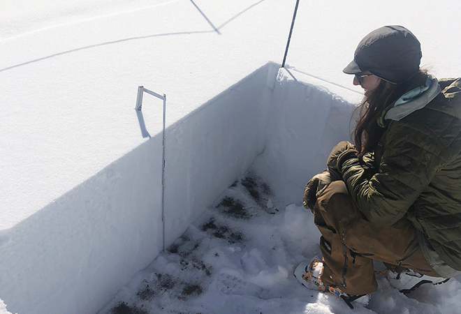
This winter the Upper East River Valley is hosting a multi-institutional collaboration, including NASA, the National Snow and Ice Data Center, Lawrence Berkeley National Lab’s Watershed Function Science Focus Area, the Rocky Mountain Biological Laboratory, Irwin Guides and the Crested Butte Avalanche Center (to name a few of the collaborators) to understand snow. Every week in January and then once every two weeks February through May, a Gulfstream III Jet will fly overhead with a radar package to measure both the density and the depth of snow. To ground truth to the measurements, teams of technicians are digging snow pits in Gothic and Irwin at the same time as the flights.
The point of this research is not to better predict your upcoming ski experience, but rather to manage water. One in six humans get their water from snow packs, and flooding caused by snowmelt causes billions of dollars of damage annually. Historic estimates of snowpack have relied upon a handful of ground-based monitoring stations that are challenging to maintain and provide only limited insights to snow cover over large geographic areas. NASA hopes to dramatically improve our ability to track snow with satellites, but first, they must develop the technology as well as the ability to process the data.
Starting in 2016 NASA began testing different types of sensing technology across the continent in a range of different types of habitats, including mountains, tundra, prairie and maritime environments. Previous work in the valley has involved a limited number of flights using LiDAR to measure snowpack and density in snapshots in time. This winter the regular flights will deploy L-band interferometric synthetic aperture radar to track how the snowpack changes across winter.
According to Dr. Jeffrey Deems, research scientist with the National Snow and Ice Data Center, and lead scientist responsible for coordinating the local campaign, “The East River watershed provides an exceptional natural laboratory to study the mountain snowpack. The coordinated research efforts this winter will produce important data sets for improving water management, understanding watershed function, and designing a future NASA snow satellite mission.”
RMBL facilities director Steve Jennison, who is helping coordinate the ground teams in Gothic, noted “We love getting out in the snow and providing our research expertise in the backcountry to support the larger effort.”
“Irwin and the CBAC are thrilled to host and assist such exciting and cutting-edge research to better understand the role our watershed plays in the greater western water picture,” said Ian Havlik of Irwin Guides and CBAC. “We will all benefit from this research both in the near term and long term with improved terrain datasets and more accurate mapping conducted by these operations.”
Executive director of RMBL Dr. Ian Billick explained that this project is part of RMBL’s larger goal of providing scientific opportunities by making the local valleys some of the best-studied ecosystems in the world. “Our goal is to make RMBL a ‘data-playground’ for scientists. Each of these studies is important in its own way. But the ability to pull these datasets together, combining recent advances in technology with the largest collection of long-term field studies, is what makes RMBL truly unique.”