 The Crested Butte News Serving the Gunnison Valley since 1999

Taylor reservoir expected to fill…
By Mark Reaman
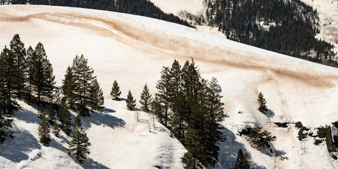
This winter’s well-above-average snow accumulation, which will help fill local reservoirs this spring and summer, will likely be heavily impacted by one big event that blew through the valley and state last week. The windy snowstorm that took place Monday, April 3 and Tuesday, April 4 brought with it a lot of dust that settled in the valley and that, as anyone who has lived here the last 10 years knows, will impact how fast all that snow melts. As of early this week, major spring snowpack runoff had not started, but as more dust is exposed with climbing temperatures, that scenario could quickly change.
The Center for Snow and Avalanche Studies out of Silverton monitors dust events in the state, and executive director Jeff Derry said the situation in the Crested Butte area caused by last week’s storm could be characterized as a “severe” dust impact.
“Judging by the Colorado Avalanche Information Center photos in the area it appears you would be considered to be in the severe area of the dust impact. We judge dust events by mild/moderate/severe,” he explained. “And we also describe overall severity for the seasonal snowpack as mild/moderate/severe. We travel the state in March, April and May to assess dust. We aim to get to your area April 17. We will go to Park Cone (up the Taylor Canyon area) which is the observation site we use that is closest to Crested Butte.”
Derry confirmed the obvious with the impact of the heavy dust on our snowpack. “Dust darkens snow surface, lowering albedo, increasing absorption of solar radiation, making snow melt earlier and faster,” he said. “Until last week, we had four mild dust events, hardly noticeable in the snowpack. Then we got last week’s event that got people’s attention as it was very noticeable and visceral.”
Beverly Richards, water resource specialist for the Upper Gunnison River Water Conservancy District, said this year’s dust impacts so far are very different from the spring of 2022.
“Up until this one event we have only had a few that were not that bad and were quickly covered up by the continuing snowfall we received in the area,” she said.
Richards continued, “Last year, numerous events occurred and along with high winds resulted in an early start to the runoff. This year we have been lucky in that there have not been any significant dust events and we have now reached the peak of snow water equivalent accumulation.
“However, as Jeff with CODOS (Colorado Dust on Snow) says, the dust is only approximately 8 cm. below the surface,” Richards added. “The forecasted warm temperatures could result in the dust being exposed and this could cause the runoff to begin in earnest. I checked streamflows this (Monday) morning and did not see any evidence of runoff beginning but this could certainly change in the next week or so. This could change some of the forecasted inflows into the reservoirs, but we probably will not know until we receive the April 15 forecast.”
Derry said this dust came from the Four Corners area from northwest New Mexico, northeast Arizona and southern Utah. He emphasized that even though this one dust event was considered “severe,” it does not necessarily mean that overall dust-on-snow conditions for the basin’s snowpack is “severe.”
“We typically see noticeable dust layers in the snow,” he explained. “So, we likely are ‘average’ in terms of overall conditions. To be certain, I need to dig a pit in your area which we will in a week and see what we see, but I never have seen one event make for overall severe conditions for the snowpack. Beverly is correct – this year is very different from 2022. Last year was a ‘severe’ dust year for the overall snowpack. The last time we declared overall dust severity as ‘severe’ was 2013. It is not a word we throw around lightly.”
In an April 6 blog post on the Colorado Dust on Snow webpage, Derry wrote that, “I guess we all knew it would happen eventually. On April 3 as I was sending out a Codos (Colorado Dust on Snow) update discussing a mild dust deposition event, a big dust storm out of the desert Southwest was making its way to Colorado. This event turned out to be widespread and a nasty event in terms of the amount of dust deposited on a relatively pristine snowpack that has essentially reached maximum accumulation. It just takes one bad dust event to change things – this one dust event is going to change the characteristics of snow melt and runoff for the duration of spring dramatically….”
Richards said that the Gunnison Watershed Basin reached a maximum snowpack level of 152% of average this year. That figure may be lower than actual because the Slumgullion SnoTel (snow telemetry) site, which is used in the local calculations, ran low for snow accumulation until recently.
Currently the basin is at 134% of average. The forecast for how much the local reservoirs will fill has been updated and Taylor looks like it will be close to full.
“Currently Taylor Reservoir is forecasted to fill 98% (1 foot below the spillway),” Richards shared. “The operations plan presented by the Bureau of Reclamation (BOR) asked for an increase in releases beginning this month in order to provide some space in the reservoir, but the timing will depend on the dissipation of ice-jams that are occurring in the upper Taylor River. Hopefully this happened over the weekend and the releases should increase any day.”
As for Blue Mesa, Richards said “the projected unregulated inflow for Blue Mesa for water supply period (April-July) is 850,000 acre-feet (134% of average as of April 7). The projected end of year content is 590,000 acre-feet or 72% of average. The BOR has stated that this will likely return levels in Blue Mesa to the standard operating levels.”
