The Crested Butte News Serving the Gunnison Valley since 1999

“This is just one tiny piece of all sorts of really cool snow science”
By Kendra Walker
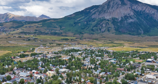
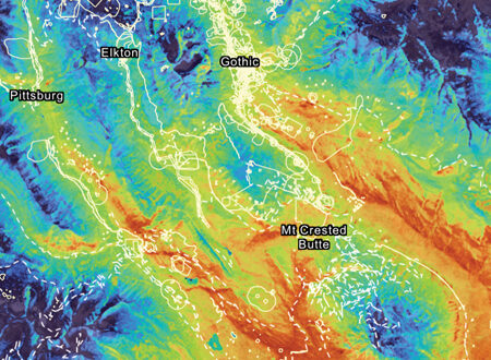
As hints of spring emerge in the Gunnison Valley and we begin dreaming of hitting the single track and hunting for wildflowers, the Rocky Mountain Biological Laboratory (RMBL) has released a snowmelt forecast map that estimates when the 2023 snowpack will disappear. It could be sooner than you think.
Developed by RMBL research scientist Dr. Ian Breckheimer, the map combines 30 years of snow persistence satellite data with real-time snowpack measurements from Colorado’s SNOTEL (snow telemetry) network. The model is updated weekly to incorporate current snowpack data and weather that has occurred.
“We’ve been working for about three years to develop these long records of snow patterns on the landscape from satellite data,” says Breckheimer. “We look at where the snow sticks around in the spring and where it tends to come off early. This map is an offshoot of a long-term project to understand snow patterns in the Upper Gunnison Basin.”
Being a big snowpack year, Breckheimer says the RMBL team realized that it would be helpful to know when snowmelt will occur. “A lot of researchers at RMBL are on nature’s calendar. It’s a big priority for the scientific community to have some way to predict when the research sites are free,” he said. “And then we realized it could be useful to other folks in the community.”
How it works
Breckheimer explains that the map uses two primary sources: historical satellite data through U.S. Geological Survey Landsat Satellite Missions and data from SNOTEL stations. “From the satellite data, we have information for how long snow stuck around in the spring and when it melted.”
Breckheimer says about 10 SNOTEL stations are in the Upper Gunnison Basin forecast area. “Those record continuously, so we know how much snow there is.”
The snowmelt forecast map is then created by looking at historical data similar to 2023 equivalent amounts of snow and conditions from the satellite data.
“This forecast essentially gives us an average of the conditions from similar years and looks at when that snowpack went away.”
“What makes this unusual is that people haven’t been predicting snowmelt data like this,” says RMBL executive director Dr. Ian Billick. “Not only does it predict for a very large area of the Gunnison Basin, but also for small areas within that: 27 square meters, which is about the size of a small backyard garden plot.”
Breckheimer says this year is most similar to 2007 and 2019 as far as snowpack is concerned. “We were just about equivalent to the 2019 snowpack until a couple weeks ago. We’re tracking a little below with the dust and melt we’ve recently experienced.”
Breckheimer notes that the forecast doesn’t account for snowpack density, temperature or radiative effects from dust because he doesn’t have a consistent record of that data. “What’s so powerful about the SNOTEL data is that we have more than 30 years on the record. We have a lot of confidence in using that data. If we develop a more sophisticated forecasting method, we might be able to incorporate factors like dust in the future.” However, he says the updated snowmelt forecast released earlier this week considers how the dust will impact the snowmelt. Billick notes that RMBL will continue integrating new data sources for even more accuracy.
And while RMBL has the “secret sauce” when it comes to its extensive archive of historical field data in the Gunnison Basin, this type of forecast can be generated for anywhere that has SNOTEL data, says Breckheimer.
“This place is often where new approaches and techniques emerge because we have so many different data streams and research taking place here,” says Billick. “A lot of things we’re doing can be done everywhere if you have the right data.”
Scientific and community benefits
The snowmelt forecast map lets the scientific community know when research sites can be reached for the season. RMBL has about 4,000 research sites, all of which can be viewed on the map. “All scientists map their research sites, and our system allows us to know exactly where they are,” says Billick.
“Additionally, there’s so much interesting biology related to the timing of snowmelt,” says Breckheimer. “It sets the start of the season for all these processes: plant growth, when the butterflies emerge, when the marmots come out, when the wildflowers bloom. It is a big event that sets the calendar for the entire year. The long-term snow patterns help us understand what drives the patterns we see in these long-term biological processes.”
Breckheimer says the map also benefits the greater community. Partners like the Crested Butte Mountain Bike Association (CBMBA) and the U.S. Forest Service can use the map to predict when trails will be ready to open. Breckheimer also hopes it helps folks better plan their visits to the backcountry. “When I’m out in the field, I see a tremendous number of cars that get stuck. Almost every season, I see someone in a snowy, muddy ditch,” says Breckheimer. “I would love people to use this information to plan their trips better and not get caught in snowbanks.”
Breckheimer also says he is working on a wildflower forecasting system based on this snow data, which will eventually provide the community with estimates for peak wildflower times.
Looking ahead
Overall, Breckheimer says the data reveals long-term trends toward earlier snowmelt. “This is especially true at lower elevations, between Gothic and Crested Butte, where we have seen a shift of about a week-and-a-half toward an earlier spring on average. We’re already starting to see the impacts of climate change on snow in the basin. Years like this are interesting because it’s a high snow/warm spring. We haven’t had many of those in the records, so I think it will be an unusual year based on what we’ve seen so far. It’s possible this year will be somewhat different from historical years.”
Billick notes this snowmelt forecast model is part of RMBL’s larger efforts to integrate rapidly emerging technologies involving big data, sensors, mapping and plane/satellite data with RMBL’s historical research strengths. “It is super exciting from a scientific perspective to combine these new technologies with old research. We have a unique combination of long-term research and recent investments in hydrology and atmospherics that make the Gunnison Basin the most intensively studied ecosystem in the world,” he says. “There are a whole bunch of possible data products, and this snowmelt data is just one of those. We can estimate soil temperature, air temperature, productivity, plants when they are greening up and browning down, etc.,” says Billick of RMBL’s Spatial Data Platform. “RMBL is extending these tools to support management agencies and other key stakeholder groups.”
“This is just one little piece of all sorts of really cool snow science,” says Breckheimer. “We are starting to understand the snowpack better, how our systems generate snow and then how it makes its way down the basin. It can help us better understand how to sustain our water resources in the West. This forecasting system is an entryway into learning more about snow science and its tremendous impacts.”
To view RMBL’s snowmelt forecast map, visit https://arcg.is/0yeb0a0.