The Crested Butte News Serving the Gunnison Valley since 1999


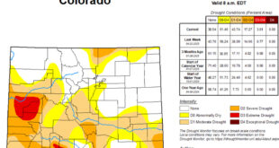
Several years of work culminating
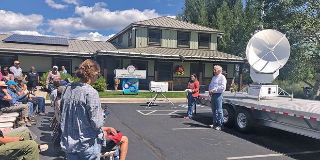
[ By Katherine Nettles ]After years of preparation, a new gap doppler weather radar is being installed in Gunnison County next month and as a leading-edge technology it is expected to vastly improve local streamflow and weather forecasting as well as provide early detection of wildland fires. It should be up and running by mid-September.
The weather radar equipment is sponsored by the nonprofit organization Western Water & Weather Intelligence Center (W3IC) and will be operated and maintained by Advanced Radar Company (ARC) out of Frederick, Colorado. The radar made a stop at the Gunnison River Water Conservancy District (UGRWCD) in Gunnison for a community presentation and public viewing in mid-August before moving on to its home at Big Mesa west of Gunnison where it is now being calibrated and having a meter added to get power.
The radar’s arrival in Gunnison is the result of a partnership between Gunnison County, UGRWCD, W3IC, ARC and others; the county and river district will be able to use the data in exchange for working with the nonprofits to allow them the opportunity of placing the radar in the Gunnison Valley. W3IC hopes to launch a capital campaign based on this project and eventually place many more such radars that can overlap across the Rocky Mountain west.
The Big Mesa radar will be the first of the nonprofit’s devices to be placed and is meant to benefit local water, weather and fire personnel while also demonstrating the benefits of bringing this technology to rural areas and creating better redundancy.
The radar itself, as described by ARC president Neil Brackin, is, “A solid state dual polar X band weather radar with a narrow beam width for precision data accumulation and with the operational capabilities and range for full coverage in this critical water basin.”
Brackin commented that this data will be used to generate a series of water resource, fire detection, wind and weather-related forecasting products which will result in significant enhancements for weather services in Gunnison County and a critical area in the headwaters of the Colorado River Basin.
“We’re getting ready to deploy the radar,” confirms Vern Tharp, W3IC President. The radar and possible future radars are not meant to replace the National Weather Service, he notes. “The National Weather Service remains the premier weather forecasting resource for rural America. The National Weather Service still issues severe weather alerts. However, in the areas of these numerous gaps in weather radar coverage, W3IC offers local weather, water and fire related personnel some additional and timely decision support tools. Also, we intend to provide our weather radar data directly to the National Weather Service via the existing National Mesonet Program within NOAA (National Oceanic and Atmospheric Administration).”
Considering fire
The radar was initially designed to improve stream flow forecasting and weather forecasting, but developers say the wildfire detection has more recently caught attention as a major benefit of the radar’s capabilities as well.
“This was based on a water study that everyone began for streamflow forecasting. This is important, but the wildland fire issue has become more pressing,” says Tharp, as wildfires have become more prevalent across the west.
“Because our radar can see about 400 square miles, based on a 60-mile radius, it can see that smoke plume at a distance,” he says. “It’s becoming as important to our strategy as the streamflow issue.”
Tharp notes that while fires may begin on federal land most of the time, they don’t stay on federal land and can spread to neighboring subdivisions and throughout municipalities. “Homes and properties are getting burned now too in the west,” he says.
Although the memorandum of understanding (MOU) has been in place for the entities involved for a few years now, Tharp says the decision to include wildland fire was an additional consideration that needed fine-tuning. “We needed a little bit different resolution with our radar camera, so it has better attenuation to see the moisture content and detect smoke plumes,” he says.
A capital issue
An organization called the Colorado Wildlife Foundation funded the $1.2 million to build the radar, while the site preparation, archeological inspections, soil testing, design work for the building, land survey and bringing in power cost another $128,000.
The idea is to raise funds to build more such radars. Tharp says that although the federal government regularly works on state-of-the art technology such as the gap radars, the innovative forecasting tools rarely make it past government projects. He wants to raise more capital for future projects from within the private sector.
“The government has developed $24 million wildland fire helicopters to stop fires in the early stages, but they are tools you can’t utilize if you don’t have the detection,” he says. “You can’t do early intervention if you don’t have early detection. Xcel Energy is putting cameras on their power lines, which is also helpful at detection but this is yet another tool. Once fire begins, having hyperlocal wind speeds and directions is critical. It can predict changes that protect firefighters, and prevent loss of life. And that is at no additional cost, because the radar is on 24/7.”
The radar being installed at Big Mesa will likely be considered the first prototype, and will remain on a trailer to demonstrate its mobility although other infrastructure has been put in place to support it.
“We decided to put it on a trailer (a cost of $60,000) rather than a permanent structure for cost efficiency and also to demonstrate the portability of this structure,” he says.
“Our mission is to form a series of public-private partnerships designed to provide timely water, weather and climate intelligence and forecasting tools to support effective local decision making in rural cities and counties throughout the western states where the federal government has simply failed to do so,” says Tharp. “We want to be a catalyst for the deployment of dozens of these gap radars across the west. We see one radar and the data it can produce. If we could put one in Durango or somewhere else in that region where that data can overlap, and if we can get three or more, it will be ideal.”
Ultimately, Tharp says they would like to install 30 or more and spread into the Four Corners region, but the start-up effort requires approximately $15 million more to get a critical mass of seven or eight radars and demonstrate the model. “Then the private marketplace could take over,” he says. “The entities that need this are counties and cities and water management districts who do not have the funds for the technology.”
Tharp says there is already one partner in the area who wants to pay for the data, but they cannot yet be identified as they are not yet under contract.
UGRWCD general manager Sonja Chavez explained to Gunnison County commissioners in a recent update that this has been a project in planning for several years between the UGRWCD, W3IC, Gunnison County, the BLM and other beneficiaries.
“All of us who live in this valley recognize that there have been gaps in accurate weather data and forecasts. We are excited to see this project come to fruition and begin aiding in our streamflow forecasting across the Gunnison Basin,” she said. “It also benefits our regional airport, recreational tourism, rural flight-for-life services, wildland fire detection and fighting, agricultural producers and critical scientific and hydrologic research happening in our headwater community.”