The Crested Butte News Serving the Gunnison Valley since 1999

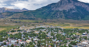
More closures could be coming in Irwin and Tin Cup
By Alissa Johnson
There will be a lot fewer places in the upper East River valley to park a motorhome or camping rig next summer. The Forest Service announced this month that it is restricting dispersed camping in more area drainages next year. The move comes in response to increased use and resource damage, and will implement restrictions outlined in the 2010 Gunnison Travel Management Plan.
“The amount of use, the levels of use, the seasons that it is occurring in and other factors that are involved, including the people we are seeing, have led to huge impacts,” Lee Ann Loupe, USFS public and legislative affairs officer, said.
Loupe pointed out that the level of use cannot be sustained without damaging resources and the recreational value of the land, and it creates conflicts between recreation users and landowners.
The agency is seeing sustained dispersed camping from Memorial Day to Labor Day and beyond, compared to historical camping patterns, which took place primarily during hunting season. The increased use has led to more campers, the development of what the agency calls user-created roads and spurs, and the increased use of trailers, motorhomes, and group camping.
Altogether, these factors are causing the permanent loss of vegetation, soil erosion, habitat loss for wildlife, user conflicts and sanitation issues.
As a result, beginning Memorial Day Weekend in 2017, the agency will implement what it calls restricted dispersed camping access in the most affected corridors, including but not limited to Gothic, Washington Gulch, Slate River, Kebler Pass, Cement Creek, Spring Creek, and Taylor Canyon.
Motor vehicles, including RVs and motorhomes, will be restricted to parking one vehicle length from the edge of the road surface—the key being that this will be allowed only when it’s safe to do so without causing damage to natural resources or facilities.
That is a change from current allowances, which vary “by the area. In some cases it could have been up to 300 feet, but again, without causing resource damage,” Loupe said.
Loupe called the latter an interesting concept to define, pointing out that one vehicle driving off the road might not create resource damage, yet when others follow, damage quickly escalates.
According to a Forest Service press release, these restrictions were already identified in the 2010 Gunnison Travel Management Plan Environmental Impact Statement and Record of Decision (ROD) and were subject to extensive public comment at the time.
“We have been aware of this issue since the analysis of Gunnison travel systems. We have focused on implementing road and trail decisions made in the ROD until now. However, recreational use in these areas is at a point where we need to take action,” John Murphy, Gunnison district ranger, said.
Forest orders will also be proposed for seasonal dispersed camping closures in Irwin and Tin Cup, similar to what was implemented in the Gothic corridor in 2016. When asked if the camping closures would continue in Gothic, Loupe said she is not aware of any proposed changes for the corridor.
The Forest Service also plans to install signs communicating the existing 14-day camping limit and prohibition of camping within 100 feet of lakes and streams. The agency will also establish a regulation regarding the transport and storage of food due to people/bear encounters.
Loupe anticipates the need for additional resources to educate forest users and enforce the regulations, but doesn’t yet know what that will look like. For now, according to the press release, the Forest Service will consider stakeholder input for the Irwin and Tin Cup areas this fall and other areas of concern as they arise.