The Crested Butte News Serving the Gunnison Valley since 1999

STOR forming subcommittee for recommendations
By Katherine Nettles
A picture of a potential multimodal recreation path between Crested Butte and Crested Butte South is beginning to take shape for the North Valley, and if approved by community stakeholders and Gunnison County commissioners, it could be under way in the next couple of years. The Gunnison County Sustainable Tourism and Outdoor Recreation (STOR) committee received an update last week with the results of an engineering study for the proposed path, dubbed CB2CBS, which would offer an alternative route for bikers and pedestrians to move between the two areas of the North Valley and add connectivity for communities along the route.
The consulting firm Design Workshop shared the results of its six-month study which began in May 2023. This included a partial design and engineering plan, cost estimates, funding ideas, an implementation strategy, and results of public input for different trail alignments along Highway 135.
The firm developed three possible alignments along the highway and shared them with the community during an open house in September. Based on the community feedback during the open house and an online survey, the preferred route was Alignment A, running from Brush Creek Road to Cement Creek Road, approximately 4.7 miles on the east side of the highway, and continuing approximately half a mile within the highway right-of-way along Cement Creek Road into CB South, terminating at Teocalli Road.
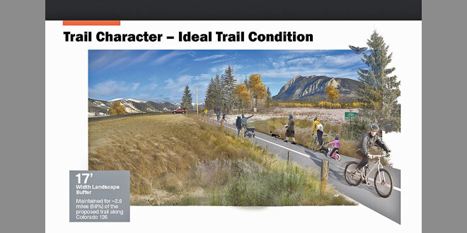
“Support for Alignment A was based on the community’s perception of its respect for private property and safety. Generally, participants from the community prefer that the proposed alignment utilizes the existing right of way, and wherever possible, limits the intrusions and interference with private property ownership,” according to the planning document. The proposed trail alignment (A) would be 12-feet wide in most areas, with a 10-foot width in a few instances where design constraints necessitate.
The alignment could be used seasonally or year-round, to be determined based on maintenance and upkeep requirements and discussion with Colorado Department of Transportation (CDOT).
The alignment minimizes interaction with the highway and uses additional signage and landscape buffers to promote safer driveway and roadway crossings.
“While a number of comments in the community survey expressed a preference for a trail alignment across private property, the STOR Committee, county staff, and the consultant team have not established that there are enough willing landowners to create a feasible alignment that option has not been delineated,” the document states.
Design Workshop indicated that most community feedback also indicated a preference for an easier, more passive trail experience that acts as a connector rather than a more difficult route or one with extensive programming. The majority also wanted to see the trail connect to existing bus stops along Highway 135, offer trail markers and trash and recycling. Among chosen modes of transportation, the vast majority (97%) indicated an interest in using it for biking, 75% indicated an interest in walking and 71% indicated an interest in Nordic skiing.
The study included a comparison of similar mountain community multimodal trails in Jackson, WY, Telluride, Aspen, Carbondale and Moab, UT. These comparison trails averaged 12-20 foot buffers from a highway and Gunnison County public works director Martin Schmidt summarized, “Everyone I spoke to is adamant that [multimodal trails] are better than shared roads.” None has had a trail user get hit, although one had trail damage. He said every community has a portion of the trail that is close to the highway.
Engineers working with the firm said they used the criteria of staying 17 feet from the edge of the highway to the edge of the trail to allow for plows and snow storage, with an additional five to eight feet of highway shoulder beyond that. That width would go down to 10 feet in one location due to proximity of the right-of-way to the highway. The trail grading would be an average of 2%, with a 6-8% grade in some places and designed for a speed range of 18-30 miles per hour with high sight distance or visibility.
The study also included a corridor and wildlife inventory analysis which determined that wildlife impacts would be lowest along the highway, and recommended using minimal, wildlife-safe fencing, bear proof trash/recycling and leash laws for all dogs.
Costs and implementation
The project is estimated to cost between $4.2 and $8.6 million, which includes some retaining walls, a 100-foot pedestrian bridge to cross the Slate River at the “dip,” considerations for storm drainage, irrigation ditches and a 20% contingency built in for unanticipated design additions. The cost difference would depend largely on what surface materials are chosen, with pavement adding $4.5 million to the cost of the project as opposed to using gravel. Schmidt said that maintenance-wise, concrete pavement acts like a bridge and lasts longer than asphalt before cracking.
“A lot of the people at this table are very avid outdoors people, but a lot of the people who would be using this trail are not,” said Schmidt of considering a smoother surface material. He said the reality is there would be dirt work to do in preparation either way.
Next steps
Design Workshop suggested an action plan for implementation if the county approves the trail. This includes adding the trail to the county capital improvement plan, identifying potential funding sources such as grants, refining the trail design with more survey work, determining if it would be year-round or seasonal, and planning construction in coordination with the Brush Creek intersection changes (the intersection at Brush Creek is being redesigned by a different party to tie in with the Whetstone housing project), while finishing the entire trail over one season. Design Workshop also suggested considering possible future trail connections.
The STOR committee then discussed how to develop consensus about the trail, and decided to form a subcommittee.
STOR member Ian Billick said he would like feedback from the Spann family at the committee level, and STOR member Mark Voegeli added, “I’d like to hear from CB South,” since CB South does not have a STOR member. Others agreed, and the committee is being directed to include those specifications. The subcommittee is scheduled to meet before the next STOR meeting in January and will determine how long it might take to come back with a recommendation. If a consensus is reached, staff would bring it to county commissioners for consideration.
STOR member Dave Ochs said that there are still conversations about trying to find an ‘off-highway’ alignment for the trail as well. “We are aiming to explore all of the options, which will take some time, in an effort to identify the best route –whether that’s on or off the highway,” he said. “If we exhaust the options and have realistic opportunities to pursue, I hope we can rely on the community to decide what is the most desirable, then charge 100% ahead at making it happen.”