The Crested Butte News Serving the Gunnison Valley since 1999


“We need to talk about housing and habitat conservation in the same sentence”
By Katherine Nettles
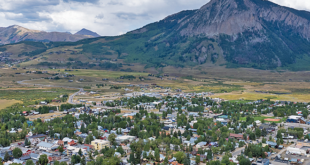
It’s no secret that Gunnison County struggles to balance human population growth and land development with preserving open space and wildlife habitat. This struggle mirrors those of many counties across Colorado and the Rocky Mountain region, and a new Wildlife Planning Support Tool has been customized for the Gunnison Valley and surrounding region to aid in calibrating human impacts using technology and mapping. Gunnison County leaders agree it will be an asset in planning and policymaking.
This Colorado Parks and Wildlife Commission (CPW) created its Gunnison County Wildlife Planning Support Tool as part of a regional partnership with Chaffee and Lake counties, having been directed by the state to develop regional priorities to balance recreation with conservation. The partnerships are meant to inform a larger, statewide plan in the future.
CPW acquired a state grant in 2022 to establish its partnership with nearby counties and to expand the wildlife tool Chaffee County has already developed into something more regional. CPW worked with Gunnison County’s Sustainable Tourism and Outdoor Recreation (STOR) Committee to create a tool specific to Gunnison County by combining maps identifying land ownership, human impacts and wildlife needs.
CPW’s Gunnison area wildlife manager Brandon Diamond presented the final Gunnison County product to county commissioners in late August.
The tool combines three maps of Gunnison County created with GIS (geographic information system) models: a land ownership map, a human disturbance map and a wildlife habitat and sensitivity map. The land ownership map identifies everything from city and county land to wilderness areas, state lands, conservation easements and private land.
The human disturbance map is more dynamic, including all roads, homes, driveways, businesses, recreation areas, cell towers, resorts, coal mines and trails within the county.
A yellow buffer highlighted the peripheral area impacted by the physical footprint. Calculations show the distance wildlife may keep away or take flight when in proximity to a hiker, a biker, a highway or ATVs. Diamond said it is hard to assign the disturbance levels of different places seasonally, but they used all data available and made generalized high, medium and low designations. So for example, Trail 401 is ranked low disturbance, as would some other much less popular recreation trails.
The third, wildlife habitat and sensitivity map includes 80 layers for 60 different animal, insect and plant species, their seasonal habitat, migration corridors and pinch-points, mating, birthing and feeding grounds and more. It also includes data about wildlife vulnerability, legal protections, economic values (think fishing and hunting) and responses to nearby recreation.
The ultimate product of the three maps is an overlay of human impacts and habitat sensitivity, which the county can now use in numerous different ways to guide development, density and conservation.
“There is an urgency and a gravity to this,” said Diamond of the nexus between human use and wildlife/natural resource conservation. “The driving force is human population growth which leads to increasing demands on the landscape. That’s the lens I look at every day.”
Human impacts
Diamond shared conservative estimates that Colorado’s current population of about six million people will grow to around eight million by 2050. And according to the Colorado Tourism Office, the state has more than 90 million visitors per year—there were 95.4 million visitors in 2024.
“It is amazing how many people are on the Colorado landscape at any given time,” said Diamond.
Diamond reviewed that Lake County, Chaffee County and Gunnison County community surveys all presented wildlife conservation as a high value. “Wildlife depends on both public and private lands. If we lose our private lands, our base ranches, our core agricultural operations, our open spaces, wildlife is in big trouble.”
Diamond said that finding a balance with competing land uses almost always results in a loss to wildlife. “We have to take into account all of these things, including energy development, commercial development, domestic livestock, fences,” he said.
Gunnison County assistant county manager for community and economic development Cathie Pagano pointed out that in the STOR survey of Gunnison County, almost the same number of responses came in favor of prioritizing wildlife preservation and maintaining recreation. “Those can be in direct tension with each other,” she said.
Diamond described the importance of an intact ecosystem free of fragmentation for wildlife habitat and walked through common, sometimes seemingly imperceptible changes over time that increase human impacts. “We can look back 10 years later and see it even when we thought we were making good ad hoc decisions and doing the right thing.”
He shared some graphics of an unfragmented land parcel, then showed its gradual development over time to include homes, a highway, driveways, trails and camping areas, commercial development, and then the introduction of weeds.
“Humans are entitled to their place on the landscape,” he conceded. “I’m not saying all this is bad, but it doesn’t help wildlife.”
Diamond reviewed that when drought occurs, perhaps decades after the other developments, it is clear the changes have compounded impacts. He highlighted one remaining undisturbed, non-fragmented habitat on the theoretical land parcel. “At this point, that is probably where we should put our efforts and resources to protect that remaining habitat, if that is the community value and priority.” He said that would be a reactive response to conservation, but there are other areas that can be protected before development happens, or proactively.
Support tool
Diamond noted that even though Gunnison County has a lot of public lands and a lot of natural landscapes, “It is heavily developed when you start looking at the actual footprint of people on the ground.”
Pagano said the tool could help the county’s planning department and its planning commission when looking at each individual land use application.
“It can be really challenging to think about that big picture because you have this one [project] before you, and Brandon’s team might say ‘well this is not the end all, worst scenario, but this is just one more piece that adds up to that sort of comprehensive compounding impact,” she said, noting the tool could help identify areas to strive for protection.
Diamond agreed. “We look at some of the larger subdivisions that are being proposed locally, and it’s not just the physical footprint of the subdivision.” He said consideration should be made of all the new residents, their cars, their pets, trash cans, trails and everything’s effect on neighboring landscapes. Diamond also addressed peoples’ perception that if they see wildlife in their surroundings, they assume wildlife is doing fine despite development. He asked if the community wants to see elk or bears, for instance, in their front yards or in more inspired settings where they are “wild and free” versus habituated to humans.
But housing…
The commissioners discussed how they have identified an acute need for more housing on the landscape, and that can conflict with conservation needs.
Commissioner Jonathan Houck said, “We do actually have pretty concentrated development in and around our towns and sometimes we think we’re doing better than most. But we forget that some of these 35-acre subdivisions don’t have the appearance of density. But the impacts are out there, and they are significant.”
Commissioner Liz Smith said the tool reflects their intentions with the Gunnison Area Plan, the county’s current land use and zoning process for the area surrounding the city of Gunnison.
“We need to be talking about housing and wildlife habitat conservation in the same sentence,” said commissioner chair Laura Puckett Daniels. “If we have this moral duty to house people, I also feel a moral duty to future generations to protect wildlife herds and functioning ecosystems and water resources for the future.”
Pagano suggested the tool could be incorporated first by the STOR Committee strategic planning, which also considers how and for what they pursue funding. Her second idea was to use it in the county’s policymaking for future land use and corridor planning.
Commissioners and their staff concluded that while the tool does not supersede any other authority or forest plans, it will be an important guide to make decisions for the future.
Diamond, spoke to the importance of leaving a “legacy of wildness” in an era of people wanting to be everywhere. “I think our lives are enhanced by a spectrum of wildness and there is value in making sure the places like what we have here can remain in perpetuity on our landscapes. And I think this tool allows us to do that.”