UPDATE 7/27:
Lowline Fire Update Gunnison, Colorado, July 27, 2023 9 a.m.
Name: Lowline Fire
Location: 14 miles north northwest of Gunnison, Colorado, 11 miles southwest of Crested Butte, Colorado. Located on a ridge at 9400 ft. elevation between Squirrel and Mill Creeks, 3.5 miles west of County road #730, Ohio Pass road.
*Please note that yesterday’s release described the location of the Lowline Fire as north northeast of Gunnison in error. The correct fire location is north northwest of Gunnison.
Size: Approximately 681 acreS
Cause: Lightning
Jurisdiction: USFS
Containment: 0%
Threatened Structures: 10
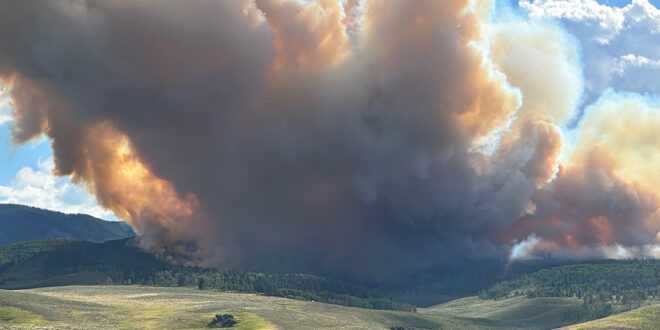
At approximately 8 a.m. Wednesday, July 26, the Lowline Fire was reported on the north aspect of a ridge between Squirrel and Mill Creeks in Gunnison County.
As of 10 p.m. last night, the fire was estimated at 681 acres in size by a Colorado Division of Fire Prevention and Control Multimission Aircraft infrared flight. Fire behavior is expected to be similar to yesterday’s with individual tree torching and creeping in spruce and aspen forest with heavy dead and down timber in the morning and fire activity picking up in the afternoon. Resources currently on scene include three engines, a helitack crew, smoke jumpers and three hand crews. Additional resources are ordered and en route. One Type 2 helicopter and two Type 1 helicopters are assigned to the fire. A Complex Incident Management Team (IMT) will assume command at 6 p.m. this evening.
No containment has been achieved, at this time. The primary objective for responders and managers today is structure protection, integrating additional resources into the response effort, and transitioning to the Complex IMT.
Ten structures are threatened in the Mill Creek and Squirrel drainages, which are under mandatory evacuations. The National Forest System Trail #438-Lowline trail is closed. Forest closure updates will be posted on the GMUG Fire Information Facebook page. County roads #818 (Wiley Lane) and #730 (Ohio Pass road) are barricaded. In the interest of public safety, fire officials ask visitors to be aware of fire traffic and avoid the area. Firefighter and public safety are the priorities for this incident.
WEDNESDAY 7/26 STORY:
Lowline Fire out Ohio Creek is growing
Calling in federal agencies and evacuating the area
By Katherine Nettles
Multiple agencies have responded to the 20 acre Lowline Fire, burning near Ohio Creek. According to the U.S. Forest Service Gunnison Ranger District, the fire was first reported at approximately 8 a.m. on July 26 on the north aspect of a ridge between Squirrel and Mill Creeks in Gunnison County.
Crested Butte Fire Protection District captain Jeremy McDonnell confirmed that the CBFPD, Gunnison County Fire District and the Grand Mesa Uncompahgre and Gunnison National Forest have all responded in coordination with one another, and have also called for federal agency assistance.
Mandatory emergency evacuation for residents in the Mill Creek Drainage west of the intersection of County Road 730 and 727 began as of 5:30 p.m. this evening (July 26), and anyone in the area is instructed to leave immediately. “Do not call 911,” wrote the Gunnison County Regional 911 Center in an evacuation notice, as all relevant agencies are aware of the situation and working to contain the fire.
McDonnell said that two bucket drops via helicopter have been used in addition to ground equipment but the fire was still growing as of 5 p.m. July 26. He said there is no confirmed cause yet or exact start time, but it is believed the fire may have been caused by a lightning strike and may have been smoldering for a time before spreading.
The GMUG press release stated that “The fire is approximately 20 acres in size with moderate spread potential, individual tree torching with active growth in spruce and aspen forest with heavy dead and down timber. Three engines and one hand crew are on scene working to suppress the fire with additional resources en route. A Type 2 helicopter from the Colorado Division of Fire Prevention and Control in Montrose is assisting. The fire is zero percent contained as of 3 p.m.
“Smoke may be visible in the area for the next several days. National Forest System Trail-Lowline trail #438 is closed and other nearby roads and trails may be impacted with smoke and firefighter activity. In the interest of public safety, fire officials ask visitors to be aware of fire traffic and avoid the area.
“Firefighter and public safety are the priorities for this incident. Fire managers would like to remind visitors to continue to be attentive of their actions and surroundings, especially in areas with dry vegetation or dead/down trees. Practice smart wildfire prevention behavior including never leaving a campfire unattended, using established campfire rings, picking safe and proper campfire sites, and ensuring that their fires are completely out and cool to the touch by using the drown, stir and feel methods.”
 The Crested Butte News Serving the Gunnison Valley since 1999


